Hydrographic surveying is the eyes of the marine world. Originally defined simply as the science of measuring and mapping coastlines and seabeds to ensure safe navigation, it has evolved into a critical discipline for offshore construction, dredging, cable laying, environmental protection, and resource extraction.
While land surveyors deal with property lines and topography, hydrographic surveyors deal with tides, currents, salinity, and acoustics. They answer one fundamental question: What does the floor look like down there?
To answer that question, surveyors deploy a suite of sophisticated technologies. Each method has its strengths, and understanding the difference between a "sweep" and a "slice" is key to any marine project.
Here are the primary types of hydrographic surveying used today.
1. Single-Beam Echo Sounder (SBES) – The Workhorse
The oldest and most common form of bathymetric surveying is the single-beam echo sounder. Operating on a simple principle, the device emits a single acoustic pulse (ping) directly beneath the vessel and listens for the echo return.
-
How it works: By calculating the time between the ping and the return, multiplied by the speed of sound in water, the device calculates depth.
-
The Output: A single line of depth points directly under the boat.
-
Best For: Navigation channel maintenance, dredging volume calculations, and general reconnaissance.
-
Limitation: It leaves massive gaps between survey lines. If an obstruction sits between the boat's tracks, the single beam will miss it entirely.
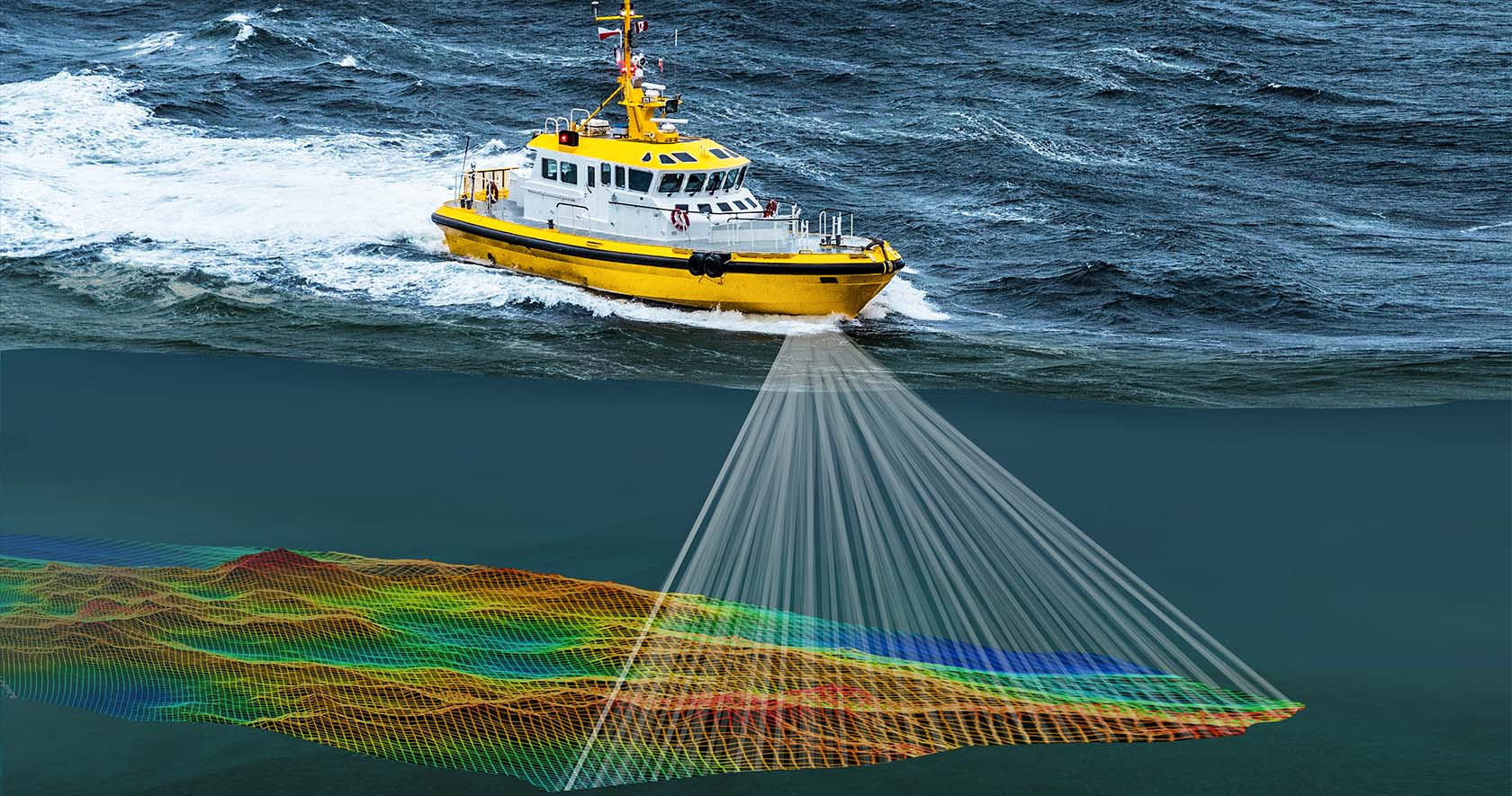
2. Multi-Beam Echo Sounder (MBES) – The Gold Standard
If you need a 3D model of the seafloor, you need a Multi-Beam Echo Sounder. Unlike its single-beam cousin, MBES emits a fan of up to 512 beams in a single ping, covering a swath of the seabed.
-
How it works: The system measures the angle and travel time of each returning beam. When combined with motion sensors (heave, pitch, roll) and precise GPS, it creates a "point cloud" of millions of data points.
-
The Output: 100% coverage of the seafloor; a photorealistic 3D digital terrain model.
-
Best For: Port expansion, submarine cable routing, wreck search, and high-resolution engineering surveys.
-
Limitation: Expensive hardware, complex calibration (patch tests), and massive data storage requirements.
3. Side Scan Sonar (SSS) – The Imager
While echo sounders measure depth, Side Scan Sonar creates a picture of the texture of the seabed. It does not measure depth accurately; rather, it looks sideways to find objects lying on the floor.
-
How it works: A towfish (an underwater vehicle) is towed behind the boat. It emits low-frequency acoustic pulses to port and starboard. Hard surfaces (rock/wrecks) return a strong, dark signal (high backscatter). Soft surfaces (mud/sand) return a weak, light signal.
-
The Output: A high-resolution, acoustic "photograph" of the seabed.
-
Best For: Locating shipwrecks, debris, pipelines, cables, and environmental habitat mapping.
-
Limitation: Poor in very deep water or murky water with high turbidity; cannot measure exact depth, only identify presence.
4. Seismic Surveying (Sub-bottom Profiling)
To see what lies under the seabed (below the mud and sand), surveyors use seismology. This is the primary tool for geologists and offshore energy developers.
-
How it works: A powerful energy source (such as an airgun, boomer, or chirp) sends low-frequency sound waves into the seabed. These waves penetrate the layers of sediment and reflect off different rock strata back to the receiver (hydrophone).
-
The Output: A cross-sectional "geologic timeline" showing layers of sediment, faults, gas pockets, and bedrock.
-
Best For: Offshore wind farm foundation design, oil & gas exploration, cable burial risk assessment, and harbor dredging pre-investigation.
-
Limitation: Low-frequency sound can be disruptive to marine mammals (requiring mitigation); slower survey speeds.
5. Magnetometry – The Metal Detector
Hydrographic surveying isn't all about sound. Magnetometry uses physics to detect ferrous metal without touching it. It measures tiny variations in the Earth's magnetic field.
-
How it works: A towed magnetometer sensor detects the magnetic anomaly caused by steel objects. When a steel wreck or pipeline is present, the magnetic field "warps" locally.
-
The Output: A contour map of magnetic intensity (nanoteslas) showing where anomalies are buried.
-
Best For: UXO (Unexploded Ordnance) clearance, locating buried pipelines or cables, searching for historic iron shipwrecks, and anchor fouling prevention.
-
Limitation: Does not work on non-ferrous materials (aluminum, concrete, plastic); requires precise "diurnal corrections" for solar magnetic interference.
6. Airborne LiDAR Bathymetry (ALB)
For shallow, clear coastal waters, boats are often inefficient. Airborne LiDAR (Light Detection and Ranging) mounted on helicopters or drones offers a solution.
-
How it works: A laser scans the surface. One frequency reflects off the water's surface, while another penetrates the water column, reflects off the seabed, and returns.
-
The Output: Rapid, high-density depth mapping of the littoral zone (0m to 50m depth, clear water only).
-
Best For: Beach profiling, coral reef mapping, disaster response (post-storm navigation), and surveying remote arctic or tropical atolls.
Which Survey Do You Need?
Choosing the right method depends entirely on your mission objective:
| If you need... | You likely want... |
|---|---|
| Simple depth for navigation charts | Single Beam |
| 3D models for engineering | Multi-Beam |
| A picture of the wreck/pipeline | Side Scan Sonar |
| Geology below the mud | Seismic (Sub-bottom) |
| Buried steel or UXO | Magnetometer |
The Future is Integration
Modern hydrography rarely uses just one method. Today’s most successful surveys use integrated systems. A single vessel will tow a side-scan sonar to find the wreck, a magnetometer to confirm it is steel, and a multi-beam echosounder to measure how high it stands off the bottom—all simultaneously.
Hydrographic surveying is the silent foundation of the blue economy. Whether you are protecting a coral reef or laying a transatlantic internet cable, you cannot manage what you cannot measure. And to measure it, you need to get the soundings right.
Need hydrographic survey services for your upcoming marine project? Contact a us to determine the right sensor mix for your specific project needs.